History of Madeira's levadas: how the water channels work
From 15th-century settlers' canals to the 63 km Levada dos Tornos: how levadas share water by giro, who the levadeiros were, and how to walk them safely today.
28 October 2026 · 6 min read
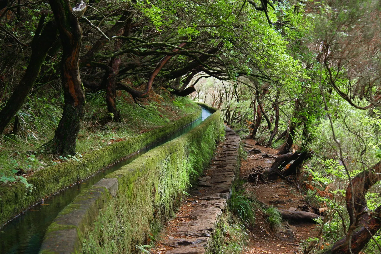
Levadas are Madeira's irrigation channels: narrow, gently sloping canals that carry water by gravity from mountain springs and the wet, forested north to farmland, towns and hydroelectric plants further south. They have been built and rebuilt for about 600 years, since the island was settled in the 15th century, and the maintenance paths beside them are now Madeira's best-known walking routes. Walking one means following working infrastructure, not a nature trail built for visitors.
Key facts
- Age: about 600 years of construction, according to the regional government's UNESCO nomination booklet.
- Public network: 103 main public levadas, according to the same booklet.
- Longest examples: Levada dos Tornos, 63 km (built 1958–1966), and Levada do Norte, 51 km (built 1947–1952).
- Oldest walkable examples in our guide: Levada do Risco (1835–1860) and Levada das 25 Fontes (1852–1890), both at Rabaçal.
- UNESCO: eight levadas covering 25.20 ha (with a 7,584.49 ha buffer zone) have been proposed for World Heritage status.
- Irrigation season on Madeira: normally May to October, under the 2026 regional irrigation regulation.
When and why were Madeira's levadas built?
When Portuguese settlers arrived, Madeira was uninhabited and densely forested. A 2021 study in the Arquivo Histórico da Madeira (Wittenberg and Rhode) describes how settlers began building canals from the start, to bring water from streams and springs to their fields. In the first hundred years, forest clearing and sugar cane transformed the landscape, and levadas also drove water mills. The study examined 21 surviving mills with horizontal rodízio wheels and falls of 4 to 35 m, used to grind grain, saw wood and crush sugar cane.
The Portuguese Wikipedia article on levadas, citing geographer Raimundo Quintal, traces a pattern of booms and pauses: expansion with sugar cane, stagnation from the mid-17th century as sugar declined and vines took over, and a new wave in the 19th century. By the mid-19th century the southern streams no longer carried enough water, so channels had to tap streams on the north side and bring the water through the mountains. That was costly, and the state stepped in for the first time. Levada do Risco (1835–1860) and Levada das 25 Fontes (1852–1890) belong to this period. Accounts compiled on Wikipedia also note that the labour of enslaved people was part of the early construction history.
How does a levada actually work?
A levada starts at its madre, the point where water is captured from a stream or spring. From there it runs at a gentle gradient in an open channel, the caixa da levada, or through tunnels, locally called furados. Beside it runs the esplanada, the maintenance path that walkers now use. Many sections are small: on the Levada da Serra do Faial, the channel averages 0.6 m wide.
Water reaches farmland through a tornadoiro, the point where water is diverted towards a plot. Distribution follows the giro: the regional regulation defines it as the time between two consecutive deliveries of irrigation water to the same delivery point. Depending on the levada, daily delivery runs from 7:00 to 19:00, from 8:00 to 20:00, or continuously for 24 hours.
One example shows how far a drop of water can travel. Water from the Levada do Risco is handed over to the Levada das 25 Fontes at the Cavalo Tunnel and continues to the Calheta I hydroelectric plant. After it has passed through the turbines it goes to a reservoir and then into two further levadas, towards Ponta do Pargo and Ponta do Sol, for drinking water and irrigation. Walk at Rabaçal and you are beside water that ends up in taps and fields on the south-west coast.
How long are the levadas, really?
There is no single official total that we could verify. The Portuguese Wikipedia article attributes figures of about 800 km of main channels and 2,300 km of secondary channels to Raimundo Quintal, speaking on RTP in 2021. Other totals between 2,000 and 3,000 km appear in guidebooks without a stated source. The firmer numbers come from the regional government's UNESCO booklet: 103 main public levadas, with individual lengths such as 63 km for Levada dos Tornos and 51 km for Levada do Norte. Treat any island-wide total as an estimate.
Who were the levadeiros?
The Priberam dictionary marks levadeiro as a Madeira term for a person who distributes irrigation water through levadas or looks after their maintenance. Sharing water by giro only works if someone keeps the channel clear and diverts the flow at the right tornadoiro at the right time. That was, and still is, the levadeiro's job. On the Levada do Norte, the UNESCO booklet points out the guard houses along the route where maintenance workers stay overnight when needed.
Today the public irrigation system is run by ARM – Águas e Resíduos da Madeira, the concessionaire of the regional water system since a contract signed on 30 December 2014. Its 2026 service regulation still uses the old vocabulary of giro, meio giro and tornadoiro.
What changed with the 20th-century state works?
The large 20th-century levadas were engineered on a different scale and for more purposes than irrigation alone. Levada do Norte (1947–1952) runs 51 km from Porto Moniz to Câmara de Lobos. Its northern section includes 19 tunnels along 7.96 km, and it supplies drinking water, irrigation and the Serra de Água hydroelectric plant. Levada do Alecrim (1953) was built in concrete over the line of an 18th-century channel. Levada dos Tornos (1958–1966) runs 63 km to the south slope, feeds the Fajã da Nogueira hydroelectric plant, and supplies drinking water to Funchal and irrigation to Santa Cruz and Machico.
The result is the multi-purpose system described in the UNESCO booklet: water for drinking, farming, traditional mills, electricity and walking. Concrete and tunnels replaced stone and wood on many stretches, but older sections survive. Most of the Levada do Risco is still in its original state, cut into the rock.
Which levadas can you walk?
The classified PR trails in our guide let you see different periods of the system:
- Levada do Risco (PR 6.1): the 1835–1860 channel at Rabaçal, 3 km each way, easy.
- Levada das 25 Fontes (PR 6): the 1852–1890 channel from the same car park, through laurel forest and heath.
- Levada do Caldeirão Verde (PR 9): a 19th-century channel in Santana, 8.7 km each way, with tunnels and long drops.
- Vereda dos Balcões (PR 11): 1.5 km along the Levada da Serra do Faial at Ribeiro Frio, the easiest introduction.
How do you walk a levada safely today?
Every classified PR trail needs a booked time slot and fee on the SIMplifica portal; see our trail booking and fees guide. The rest of the advice comes from IFCN, the regional forestry and nature conservation institute:
- Check the status first. IFCN warns that an approved, signposted trail is not a guarantee that it is safe at every time of year. Trails can be open, restricted or closed.
- Don't go alone, and tell someone your route and expected return time.
- Finish before dark. Avoid starting late in the afternoon.
- Carry a torch, a warm layer, a rain jacket, a first-aid kit, food and water, and wear non-slip shoes. Tunnels and wet paths are part of most levada routes.
- Turn back in rain or strong wind, and if you meet a rockfall, do not try to get round it.
- Stay on the marked path. Variations damage the habitat and increase the risk of getting lost.
- Emergency number: 112.
What people often misjudge is the edge. The esplanada was built for maintenance, not for crowds, and on routes like Caldeirão Verde it runs along steep drops. Let other walkers pass at wider points rather than stepping onto the channel wall.
Sources and fact-checking
Facts checked against the sources below on 28 October 2026. How we work
- IFCN / Governo Regional da Madeira — Levadas da Madeira: proposed nomination to the UNESCO World Heritage List (booklet)
- Wittenberg & Rhode (2021), Levadas e moinhos de água na ilha da Madeira — Arquivo Histórico da Madeira, Nova Série 3
- JORAM — Portaria n.º 199/2026 (8 May 2026), irrigation service regulation of the ARM system
- IFCN — Dicas para o pedestrianista (official walking safety advice)
- Wikipedia (pt) — Levada
- Dicionário Priberam — levadeiro
Photos: Jörg Schmalenberger (= JOEXX) (CC BY-SA 3.0)